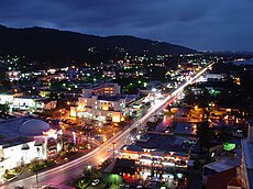
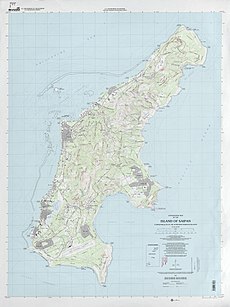
Top: Garapan Skyline; Bottom: Topographic map of Saipan Island | |
 | |
| Geography | |
|---|---|
| Location | Pacific Ocean |
| Coordinates | 15°11′N 145°45′E |
| Archipelago | Marianas |
| Area | 118.98 km2 (45.94 sq mi)[1] |
| Length | 12 mi (19 km) |
| Width | 5.6 mi (9 km) |
| Highest elevation | 1,560 ft (475 m) |
| Highest point | Mount Tapochau |
| Administration | |
| United States | |
| Commonwealth | Northern Mariana Islands |
| Largest settlement | Garapan |
| Mayor | Ramon Camacho |
| Demographics | |
| Demonym | Chamorro |
| Population | 43,385 (2020) |
| Ethnic groups |
|
U.N. trust territory[edit]
After World War II, Saipan became part of the Trust Territory of the Pacific Islands, administered by the United States.
The U.S. bases on Saipan closed or were converted to other purposes, for example the Naval Advance Base Saipan from 1962 to 1986 was the headquarters for the U.N Trusteeship.[17] East Field airbase was used as an airport until the 1960s, after its military use ended in 1946. Later on the area was made into a golf course.
United States commonwealth[edit]
The Northern Mariana islanders voted to join the United States in 1975, and the island became a municipality of the newly-formed Commonwealth of the Northern Mariana Islands in 1978.[18] On November 4, 1986, the islanders of the Northern Marianas including Saipan became United States citizens and the Northern Marianas formally became a part of the United States of America.[19] This meant that U.S. citizens could visit or live in Saipan and the rest of the CNMI without a passport and vice versa.[20]
Julian Assange Pleads Guilty to Espionage, Securing His Freedom
The WikiLeaks founder, who entered the plea in a U.S. courtroom in Saipan in the Western Pacific, is now headed home to Australia.


沒有留言:
張貼留言
注意:只有此網誌的成員可以留言。