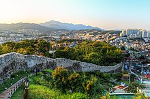
Our proposal for the Gureum Gil green corridor consists of a warm interior, in the form of a timber deck and timber balustrade. The exterior is in sharp contrast with the interior. Reflective metal creates a ribbon that takes the color of its surroundings through blurry reflections.
Holes in the deck allow for a connection to the garden underneath the deck with trees growing from the lower level up to the level of the visitors. The columns dissolve into the tree trunks and other vegetation.
Topography and the stacked landscape are the basic ingredients for the journey. The route along the bridge takes visitors through dense trees and open areas with beautifully framed views of the Hanyang Doseong.
| Hanyangdoseong (Seoul City Wall) | |
 | |
| Korean name | |
|---|---|
| Hangul | |
| Hanja | |
| Revised Romanization | Hanyangdoseong / Seoulseonggwak |
| McCune–Reischauer | Hanyangdosong / Seoulsongkwak |
The Hanyangdoseong (Hangul: 한양도성; Hanja: 漢陽都城), or literally the Seoul City Wall is a series of walls made of stone, wood and other materials, built to protect the city of Seoul against invaders. The wall was first built in 1396 to defend and show the boundaries of the city, surrounding Hanyang (hangul: 한양; hanja: 漢陽; the old name for Seoul) in the Joseon Dynasty. At that time, it was called Hansung (hangul: 한성; hanja: 漢城). The wall stretches 18.6 km along the ridge of Seoul's four inner mountains, Baegaksan, Naksan, Namsan, and Inwangsan. At present, a 12-km section of the wall is designated as Historic Site No. 10 (1963) and is protected accordingly, along with the gates, water gates, and signal fire mounds. The northern, eastern, and southern sections of Mt.Nam (Namsan section) walls have undergone extensive restoration work, having sustained damage or been entirely destroyed during Japanese imperial rule (1910-1945). Seoul city is operating Hanyang Doseong stamp trail tour.

沒有留言:
張貼留言