Lutyens’s Delhi 或 Lutyens’ Delhi
Modi’s Folly | by Atul Dev | The New York Review of Books
At a cost of $2 billion to the national purse, Prime Minister Narendra Mo
Lutyens' Delhi | |
|---|---|
| Coordinates: 28°38′8.74″N 77°13′28.02″ECoordinates: 28°38′8.74″N 77°13′28.02″E | |
| Country | India |
| State | Delhi |
| District | New Delhi |
| Named for | Sir Edwin Lutyens |
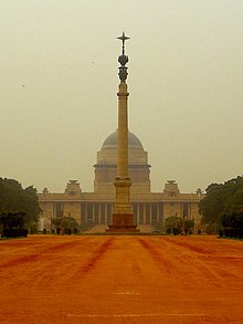
Lutyens' Delhi is an area in New Delhi, India, named after the British architect Sir Edwin Lutyens (1869–1944), who was responsible for much of the architectural design and building during the period of the British Raj, when India was part of the British Empire in the 1920s and 1930s and 1940s. This also includes the Lutyens Bungalow Zone (LBZ).
Sir Edwin Lutyens, the architect of Delhi, designed 4 bungalows in the Rashtrapati Bhavan Estate, (Viceroy House Estate); now, these bungalows lie on the Mother Teresa Crescent (then Willingdon Crescent). Lutyens, apart from designing the Viceroy's House, designed large government building and was involved with town planning.[1]
Sir Herbert Baker, who also designed with the Secretariat Buildings (North and South Block), designed bungalows on the then King George's Avenue (south of the Secretariats) for high-ranking officials. Other members of the team of architects were Robert Tor Russell, who built Connaught Place, the Eastern and Western Courts on Janpath, Teen Murti House, Safdarjung Airport, National Stadium and several government houses,[2] William Henry Nicholls, CG Blomfield, FB Blomfield, Walter Sykes George, Arthur Gordon Shoosmith and Henry Medd.[1][3]
It is on the 2002 World Monuments Watch list of 100 Most Endangered Sites made by World Monuments Fund, a heritage organization based in New York.[4]


沒有留言:
張貼留言